Train Specials

Mt. Rainier Visitor Association Blog

Sharing the beauty and information about Mt. Rainier and the lovely Nisqually Valley area with visitors from around the world.

Don’t Let the Rain Stop You

You’ve got an adventure all planned to one of the most beautiful places in the world, and now it’s raining.  Sigh.  What is there to do at Mt. Rainier without all of those spectacular mountain views?  Lucky for you – there is plenty that Mt. Rainier still has to offer, even with grey skies and some drizzle. Mt. Rainier is home to old growth forests, plenty of animals, and wildflowers and waterfalls abound, even in the rain.  Here are some ideas to make sure that you still have a fantastic time on the mountain.

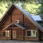
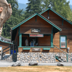
Heading through the Nisqually Entrance on the Southwest corner of the park, begin by winding your way up to 6.5 miles miles East to Longmire.  Stop and check out the Longmire Museum, open year-round. The museum is open 9-5 July 1st – Sept 2nd,  with its historical collection on the early history of Longmire, and exhibits and an information booth.  Operating hours are limited outside of peak season, so check here to plan your visit.

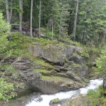
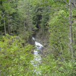
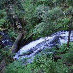
Leaving Longmire and continuing east for four miles, you’ll drive right over Christine Falls. This is a beautiful two-tiered smaller waterfall that shoots ecstatically from a slot canyon in the rocks.  You can take great photos from the road, or walk five minutes below the falls for a view of the second tier of the waterfall, framed by the beautiful reinforced concrete/rock bridge you just drove over on SR 706.

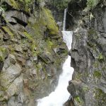
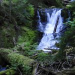
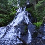
Hope back in your car heading east, and you’ll soon come to a large parking lot on your right.  Pull on over, and welcome to Narada Falls! Narada Falls is a family favorite, because all family members get to cross the reinforced concrete/rock bridge that crosses over the first tier of the waterfall on the way to the restrooms, and a short 5-minute walk gives the visitor a fantastic view of the entire two-tiered 188 foot waterfall.  The mists from the falls at the viewpoint can get you a bit damp – but you won’t even notice if it is already raining and you are wearing your rain jacket! Here there are restroom facilities and picnic tables as well.

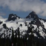
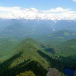
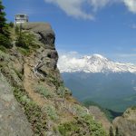
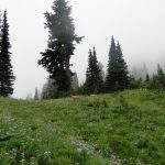
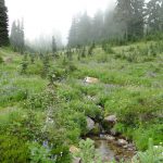
Once at Paradise, take a look around to see if the clouds will clear to give you a view of the Tatoosh Range, or if you can catch a glimpse of the mountain.  If Rainier is not out, don’t despair! Head to the Henry M. Jackson Visitor Center, open June 15th – September 1st, 9 am – 7 pm daily. There are interactive displays, videos, ranger talks, photos, climbing relics, a gift shop, and wonderful area to get warm and spread out your family’s picnic lunch and rest for a bit before heading out for more fun.

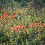
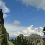
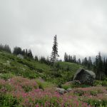
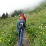
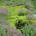
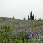
This time of year (August), the wildflowers are in full bloom as well.  A walk around the Paradise area in the mist is still beautiful. The yellow-green grasses, blue-green sub-alpine trees, and the pinks, yellows, purples and whites of the flowers pop against the grey. The animals are often out in the rain as well, so keep an eye out for marmots, deer, mountain goats, and even black bear – particularly at dawn and dusk.

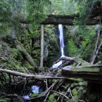
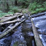
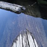
On your way back down, about a half mile after you cross over Christine Falls, you’ll see a parking lot for Comet Falls on your right-hand side. If you have appropriate weather gear and it isn’t raining too hard, the is a 2-3 hour hike round-trip to Comet Falls (3.8 miles total) is mostly protected by trees.  You’ll cross above Christine Falls after . 7 miles on a beautiful little log bridge, and you can continue on to Comet Falls if your feet are still feeling dry and comfortable. If the weather clear, Von Trump Park  and its fields of wildflowers and mountain views is an additional mile after Comet Falls, making your total round-trip hike 5.8 miles.

A few of the lower hikes in and around Longmire offer some great hikes for rainy days as well. Twin Firs, Trail of Shadows, Lower Kautz, Rampart Ridge Loop Trail, Eagle Peak, and Carter and Madcap Falls are all great wet weather hikes as well.  Look them up on the NPS website, or stop by our Visitor Center for additional information.

Enjoy the rain!

Posted on August 28, 2013

Lake George and Gobbler’s Knob

While hoards of tourists are streaming to Paradise to get their wildflower fill for the summer, it is a great time to find a hike with a view and get in some quiet trail time in the forests of the park.  Let others fight for parking! Lake George and Gobbler’s Knob Lookout are great destinations and are moderate hikes (.9 miles from the trail head to Lake George, and another 1.6 miles to Gobbler’s Knob Lookout), and there are very few people on the trail.

“What?!” you say.  “A lake, a fire lookout, and a moderate-level hike accessible to the family that can be enjoyed in relative solitude at Mt. Rainier?  How can this be?!”

I’m so glad you asked!  The Lake George/Gobbler’s Knob trailhead are on the Westside Road, which is the very first left you can make when entering the park from the Nisqually entrance.  However, there is a catch.  Continual flooding of the Westside Road has shut down public vehicle access for nearly 15 years.  The road is gated off after the first 3 miles, and is only accessible for work vehicles.

“Wait a minute,” you say.  “Then how do we get there?  How far is it from the gate to the trailhead?”

Don’t throw in the towel yet! Park your car alongside the Westside Road at the gate. The trailhead for Lake George/Gobbler’s Knob is approximately 4 miles from the gate on your lefthand side, and is impossible to miss.  Many people choose to make a visit to Lake George/Gobbler’s Knob an overnight or even two-night experience, and hike in the 4 miles to the trailhead.  There are campsites (even a group campsite) available at Lake George, and the 4.9 mile hike from the gate to the lake is relatively easy, though hikers will be packing in on a gradual incline the entire hike.  Gobbler’s Knob can then be done as an afternoon hike once the backpacks are dropped off and camp is set up, or the next morning before packing up camp. Heading out is easy, as hikers enjoy a gradual descent that is gentle on the knees.

“But didn’t you say this is a moderate hike? One where my family and I can hike 5 miles roundtrip and relax lakeside, as well as at an old fire lookout?! 13 miles and 5 miles are quite different. We were really looking for a day hike”

Settle down sassypants! You’re absolutely right.  13-miles is a different cup-of-tea than a 5-mile  hike.  But lucky for us, there are other ways to utilize the Westside Road. Does your family bike? Grab your bikes, helmets, and day packs, and enjoy a 4-mile bike to the trailhead and a .9 mile walk to Lake George. The roundtrip 8-mile bike ride and 1.8 mile hike to and from Lake George can be done easily in 2-2.5 hours, and the drive from Ashford (where the visitor Center is located) to the Westside Road gate is just over 20 minutes.  This bike and hike can be done in as little as an afternoon, and Gobblers Knob is a strongly recommended addition.

The 4-mile bike ride from the Westside gate to the trailhead is all uphill on the way in, so get an early start to beat the heat.  Mountain bikes are recommended for the gravel road, and make sure to carry an extra tube and a pump.  There is a bike rack at the trailhead, which you’ll pull up to on your left.

The hike to Lake George is easy, wide, and pleasant.  Even young children who may have freeloaded in a seat on mom or dad’s bike can make their way along this path, and the hike is short enough to feel like a cool-down for your uphill bike ride. Mt. Rainier will show her face within the first .4 miles of hiking, so make sure to peer westward through the trees to enjoy your mountain views.  Once arrived at Lake George, you can picnic with your family in shady quiet and soak in the beauty of the blue-green lake. Make sure to check out the historic log patrol cabin (it was originally built as a horse barn) that sits on the northeast end of the lake, built in 1934.

Once everyone is rested and has snacked at Lake George, continue on the trail another 1.6 miles to the Gobbler’s Knob.  Gobbler’s Knob is one of four fire lookouts within the park boundaries that are historically maintained, with stunning views of the mountain. The trail to Gobblers Knob begins by following the bank of Lake George before taking a few mellow switchbacks.  Hikers are then treated to a pleasant respite from elevation gain as the trail flattens out alongside a pond and makes its way across a small valley, before the ascent begins again and the path meanders its way up in a few more agreeable switchbacks.

After 1.2 miles the trail intersects with Goat Lake Trail, which heads outside the park and into NSFS land.  (This is another route to Lake George and Gobblers Knob – this junction can be reached after 4 miles of hiking, beginning at the trailhead outside the park for Lake Christine). You only have .4 miles left to go! This last section of trail will fly by, as the trail opens up to fields of wildflowers to your left, and then curves up and behind the huge rock outcropping on which the lookout sits.

Mt. Rainier, who has been showing her face through the trees throughout your hike, is now out in all of her glory.  You’ll scramble up the rocks alongside the lookout and settle on your own private boulder throne, or perhaps climb up the lookout stairs and lean your back against the historic 1933 building while soaking in the beauty of the mountain.  Rainier is huge from Gobblers Knob (5,485 ft.), and there she provides you with a panorama that is arguably one of the best in the park.  You can see Mt. Wow to the south and Mt. Ararat to the east, and on a clear day you can see Mt. St. Helens gray and yawning in the distance.

Have a snack.  Relax.  Soak in Rainier in peace and quiet – you and your companions may be the only visitors! The 1.6 mile return to Lake George is a moderate descent where walking sticks come in handy but the path is generally very kind.  From Lake George, the .9 miles back to the trailhead and your awaiting bike will take you 20 minutes max. The 4-mile bike ride to your parked vehicle is all downhill and also takes less than 20 minutes.  If you’re really cruising, you can get from Gobbler’s Knob to your car in a little over an hour.

The secret is out.  Grab a friend or your family, load up those bikes and get out there!

Posted on August 19, 2013

Reflection Lakes

It is that time again.  The wildflowers are in full bloom, and every person visiting Paradise leaves dazzled and in full comprehension of how the name came to be.  There are many fantastic wildflower hikes to do, but one of the stunners to be sure is the Lakes Trail, which passes by the famous Reflection Lakes. Reflection Lakes are beauty unto themselves when Mt. Rainier is out and reflecting in the lakes (hence the name), but the wow-factor only increases when the wildflowers are out in all their glory.

You can get to Reflection Lakes two ways.  Either approach from Paradise on the Lakes Trail, or you can take a shorter route from the Reflection Lakes trailhead on the Stevens Canyon Highway.  I prefer to enjoy my wildflowers and mountain scenery a bit longer, and the longer version is OUTSTANDING, so I opted to begin my stroll at Paradise.  This loop begins and ends in the Paradise Visitor Center Parking Lot, and is 5.4 miles roundtrip with a 1,300 elevation gain (and a 1,300 foot elevation drop).  Walking sticks are advised for those with sore joints.

Doing the walk counterclockwise is highly recommended, for the stunning Rainier views during the latter portion. From Paradise, you’ll begin by parking in the Visitor Center Lot.  The trailhead is where the one-way Paradise Valley Road driving loop begins, just below the Paradise Lodge.  I recommend starting early in the morning, when the cool air feels fresh and smells sweet, and before the bugs come out.  The insects can be really intense one it warms up, and are particularly bad at dusk. I was lucky enough to see a fox, four deer, and six marmots on my walk, so keep an eye out for animals!

You’ll begin be descending fairly steeply (this is the only rocky portion of the trail) into beautiful subalpine firs and fabulous meadows. The trail flattens out a bit at the bottom, and you’ll cross over the Paradise River and pass by some beautiful little falls.  After a few hundred yards, you’ll cross the Paradise Valley Road and head uphill up over Mazama ridge, before heading downwards again towards Reflection Lake. The Lakes Trail joins the Wonderland Trail for a short way while passing by Reflection Lake.

You’ll reach Reflection Lake 1.7 miles from the trailhead. After passing Reflection Lake and a pond alongside it (this .2 miles is alongside the Stevens Canyon Road before you dip back into nature), you’ll curve around to the left and have the option of following the Wonderland Trail towards Paradise River Camp, or continuing on the Lakes Trail.  I opted to continue on the Wonderland Trail for a few hundred feet, and was rewarded with a beautiful view of Louise Lake.  After snapping a photo, return to the Lakes Trail and head upwards for a half mile, before arriving at Faraway Rock for an excellent view of the Tatoosh Peaks and Louise Lake.

A short uphill grade from Faraway Rock (.2miles) will have you passing by two ponds on the right, and a lovely marshy area to the left before bringing you to a decision on whether to continue on the Lakes Trail for 2.6 miles, or to take the High Lake Trail for 2.2 miles.  The High Lake Trail cuts to the left through the trees and rejoins up with the initial first mile leg of your walk.  I opted to stay with the longer Lakes Trail (following Mazama Ridge) so I could avoid re-tracing. This loop continues above Paradise and comes back down by the Paradise Lodge, ending the hike in fields of wildflowers with Mt. Rainier spectacular in the background.

But I’m getting ahead of myself.  As you head right at the ‘Y’ in the road to continue on the Lakes Trail, you’ll pass by a vibrant green meadow to your left and then round the corner to have Rainier literally in your face.  She is too large and beautiful and close to capture in all of her beauty, but you’ll snap a hundred photos trying! Every step the next mile for me was a spiritual experience. I was wading through rippling oceans of Lupine, my eyes darting across fields to take in the fireworks of Magenta and Harsh Paintbrush, American Bistort, Yellow Arnica, Rosy Spirea, White and Pink Heather, Subalpine Daisies, and Sitka Valerian  – all identified using the Mount Rainier Subalpine flower gallery . There were countless others weaving together the landscape, with stunted firs framing the mountain.

The climb is a pleasant gradual incline and mesmerizing at every step.  After about a mile, the trail meets with the Skyline Trail for the final 1.4 miles. From here on, you’ll begin running into considerably more people.  The marmots abound, and the wildflowers change with every dip and turn.  You’ll have a llittle ascent into a watershed, then have a bit of a climb, before the path definitely turns itself downwards and gently propels your feet towards the Paradise Lodge/Visitor Center Parking Lot.

There are more stunning photos in every direction – of the mountain, wildflowers, waterfalls, and the Tatoosh Range. The earlier hikers hit the trail, the less people there will be sharing the popular Skyline Trail at the end of the walk.  Set an alarm and get out there by 7 am and enjoy – I’m getting excited for you and this fabulous adventure you’re going to have.

Read more about accessing Reflection Lakes from the Stevens Canyons Road trailhead here: http://www.visitrainier.com/pg/hike/9/Reflection%20Lakes

Posted on August 13, 2013