Train Specials

Mt. Rainier Visitor Association Blog

Sharing the beauty and information about Mt. Rainier and the lovely Nisqually Valley area with visitors from around the world.

Indian Bar

Oh Indian Bar.  To be clear, this hike is not for the weak or weary.  This hike is a hard stretch of the Wonderland, with 14.5 miles round-trip and a 2,900 foot elevation gain on the way in (800 on the way out). Is it worth it?  Absolutely.  A hundred times over.

In an interview with the backcountry carpenter at Mt. Rainier, see blog here: (http://mtrainierblog.com/2013/07/07/stories-from-the-mountain-meet-mt-rainiers-backcountry-carpenter/)  he said that Indian Bar is one of his favorite places in the park.  Furthermore, he said that he had never NOT seen a bear at Indian Bar (sorry for the double negative), and sightings included a mother bear with three cubs, and a six-bears-in-one-day day.  Bears, wildflowers, dozens of waterfalls, and a babbling brook all in a private, wide-open valley.  YES PLEASE!

Indian Bar can be reached from two different access points – beginning from Box Canyon or from Fryingpan Creek Bridge (taking the the Summerland Trail from the White River side of the park).  I’ve done the Box Canyon route, and will focus on this route for all intensive purposes.  The Box Canyon trailhead is on Stevens Canyon Road, 11 miles east of the Longmire-Paradise Road. The gravel trail (with a sign) is directly across from the parking lot.

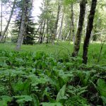
The first mile-and-a-half allow hikers to pass alongside Nickel Creek and another small creek with a mild grade. The next mile and a half are tough – there is a lot of elevation grade without much reprieve, and the area is all forested – not allowing for scenic overlooks until the 3-mile mark. At three miles, hikers will reach the crest of the Cowlitz Divide, which hikers will follow for the next four-and-a-half miles. Off the right hikers can settle themselves into a moderate sized field of wildflowers with nice views southwards, to drink and eat trail mix before continuing north and climbing onward.

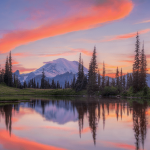
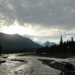
As hikers continue onwards on the ridge, the trail gradually opens up.  Mt. Rainier will start to show its southeast side ahead and to the left through the trees, and the trail will follow the contours of the ridge, at times quite steep, but allowing hikers to rest on some flat stretches, and enjoy the wildflower meadows as they widen and beckon. Finally, the trail widens to show Mt. Rainier in all of its glory, with a colorful valley in the foreground. This is the high point of the trail at 5,914′ and from here, hikers will descend 800′ into the valley where Indian Bar sits in a huge open meadow.

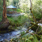
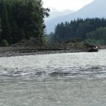
The Ohanapecosh river splits the meadow in two, and the Indian Bar shelter beautifully sits to the west side of the river, its open side facing the flowing water.  Animals frequent the meadows north of the shelter and camping areas, and in late spring there are many waterfalls pouring down the lava cliff faces high above the valley. The backcountry camping area is southeast of the shelter about 100 feet, and sits right above Wauhaukaupauken Falls, which are small but beautiful.

Once you’ve set up your camp and rested a bit, it is recommended to clamber up the hill above the camp.  Elk sightings are almost guaranteed when the animals are in rut in September.  Remember always to give animals plenty of space.  Bull elk can be extremely aggressive in mating season, and you should take care never to surprise a black bear.  Take extra precautions around the black bear if there are cubs around.  Never get between a mother and her cub, and make sure to make plenty of noise when hiking at dusk and dawn, so as not to catch a bear unaware and on the defense.

This hike is generally snow-free from late July – September, and the wildflowers are out in full effect late-July to mid-August. If hikers arrange for a car drop-off, the Box Canyon hike can be combined with the Summerland trail to the trailhead at Frying Creek bridge (another 8.7 mile hike), for a one-way 17 mile hike through some of Mt. Rainier’s most beautiful country.

If you choose to do the Box Canyon trail in and out of Indian Bar, it is most definitely recommended as a two-day hike, so make sure that you apply for the appropriate backcountry camping permit, which must be arranged in person. Wilderness Camping and Climbing permits are available at the Longmire, White River, and Carbon River Wilderness Information Centers (WICs) and at the Paradise Climbing Information Center during the summer season. Permits are also available at visitor centers.

Posted on August 7, 2013

Cathedral Falls

The Nisqually Valley is an amazing and wonderful place, and Mt. Rainier is arguably one of the most beautiful places on earth.  Sometimes it is hard to wonder why we’d ever venture out of the valley for more beauty, but sometimes a short day trip can have spectacular results.  Cathedral Falls, located in the Cowlitz Valley – is just such one of these places.

Mt. Rainier has waterfalls galore.  But Catheral Falls is spectacular.  It feels like you could be in Costa Rica or in Western Africa, but with huckleberry bushes and pine and cedar trees surrounding you.  What’s more, the drive to Cathedral Falls is only about 1.5 hours from Ashford, and about 45 minutes if you are staying in Packwood or Morton – which happens often to folks who don’t make reservations on busy summer weekends. The hike is easy, and you get to traverse behind the waterfalls on the trail! Family friendly, and dogs are welcome. Read on for the details!

To get there, you’ll need to head towards Riffe Lake.  From the Ashford Visitor’s Center, head west 6 miles to Elbe, and take a left on Hwy 7 to Morton.  Once in Morton, take a left on Hwy 12. Head east for about 8 miles, and take a right on Kosmos Road, and take your next main left on to Champion Haul Road.  Follow this road along Riffe Lake and over the bridge, and continue following the road to the right onto a dirt road.  Follow this for a bit less than a mile, and take a left on another dirt road.  This road has a gate that should be open, posting that it is privately owned by a timber company, but publicly accessible.  Rules and regulations are posted.  Carry on, and the dirt road will take you into Gifford Pinchot National Forest! You’re almost there.

Drive for about 4.5 miles, keeping on the main dirt road and curving uphill and to the left.  Just when you’ve thought your lost your way, you’ll see the cars parked at the trail-head.  Unload your kids, dogs, snacks and packs, and hit the trail! The path is wide, well-maintained, and obstacle free.  The shady forest is cool and sweet smelling, huckleberry bushes are everywhere, and wildflowers liven the trail in late spring/early summer.

After about a mile, you’re there! And it will take your breath away. The falls launch 248 feet above, pummeling over an overhang high above, and creating a sheet of water that visitors can walk behind, or marvel at from various viewpoints to either side/front of the falls.  The trail takes all hikers behind the falls, and aside from a spactacular vantage point, visitors can linger in the cavernous hollow in the rocks that gave Cathedral Falls its appropriate name. At the bottom of the falls, the water has pounded the rock into a gentle swoop that loops the water around in a semi-circle before continuing it on its way.

The falls are most spectacular when the falls are running when the water is at its highest, from early May to mid-June, or after a heavy rain in the fall.  The falls will lose most of their power by late-June, but a trickle should continue through the year.  This is a great hike for a rainy day – hikers are protected by the tall cedars and pine trees, and hikers can continue their hike after the falls if they are interested in exploring further.

A wonderful family outing awaits at Cathedral Falls – enjoy!

Posted on August 4, 2013

Rampart Ridge

The wildflowers of Mt. Rainier are just starting to come out in full force, but so are the crowds.  If you have done your wildflower hike and have an extra morning where you’d like to get back ont he trails, or you’re just looking for a mountain view and a trail free of the crowds, Rampart Ridge is a nice moderate day hike that can be managed in 2.5 – 3 hours.

The Rampart Ridge trail is a 4.9 mile loop that begins and ends at Longmire.  We recommend doing this hike clockwise so that you can enjoy the view of Rainier when it comes into view on east side of the ridge.  To begin, park in the Longmire parking lot and cross the road (if it is clear Mt. Rainier will be spectacular across the meadows), and head to your left.  You’ll see a sign for the Trail of Shadows (which is also a loop) and Rampart Ridge, and continue clockwise.

The first .2 miles of the trail overlaps with the westernmost part of the Trail of Shadows trail.  After crossing a wooden bridge and making your way through lush, marshy foliage with Devil’s Club and Skunk Cabbage, you’ll set foot on drier soil and begin marveling at the old growth firs towering above and the calming shade they provide.  Keep an eye out for the sign that will point you left to the Rampart Ridge Trail, and here the slope will start to incline slowly.

The trail begins gently for the first half mile as you gradually hike through the trees, and then gentle switchbacks will keep you heading up the mountain for another 1.5 miles.  The trail is never unbearably steep, and the path is wide and free of obstacles for 98% of the route, with the exception of a few loose stones on the ridge.  There is a 1,300 foot elevation gain in total – an intermediate to advanced hiker will be able to make his/her way up the mountain in no time, and even beginning hikers or families will find the trail do-able with a few breaks along the way.

After two miles, hikers reach the west end of the ridge, and a small viewpoint at 3,700 feet. For the next mile, the trail follows the ridge, offering glimpses of Longmire and Longmire Meadows below and to the right, and with Mt. Rainier peaking through the trees directly ahead.  There are a few small spurs off the main trail where one can take a few steps and take a glorious photo of the mountain, but Mt. Rainier comes into full view the last quarter mile on the ridge, allowing mountain lovers and photographers to gaze at their heart’s content at the huge and glorious mountain before them.

The trail will eventually join with the Wonderland Trail.  Follow the trail to the right and descend the 1.8 miles towards Longmire.  This is an enjoyable descent – nothing too hard on the knees and minimal switchbacks.  You will descend through the trees for a little over a mile before you’ll notice the ecosystem changing back to the marshy dense foliage similar to the start of the trail. A little creek will babble alongside you to your left, and you’ll walk over a lovely boardwalk until you meet the Mountain Hwy/SR 706. Cross the highway and continue going straight  – note that this is not well-marked, but continue on and you’ll me just fine. After .3 miles walking int eh woods alongside the road, you’ll emerge just above Longmire, and can make your way back towards your car.

Don’t forget to take one look back at Mt. Rainier, beaming over the Longmire meadows in all her glory.

Posted on July 28, 2013