Train Specials

Mt. Rainier Visitor Association Blog

Sharing the beauty and information about Mt. Rainier and the lovely Nisqually Valley area with visitors from around the world.

High Rock Lookout

We’re thrilled that the great weather has brought thousands of visitors into Mt. Rainier National Park the last few weeks.  However, long lines to enter the park has people asking about hikes and activities that are available in the Nisqually Valley, just outside the park entrance.  Don’t worry – there are plenty of hikes and activities to enjoy in and around Ashford, where our Visitor’s Center is located.  One such hike is the High Rock Lookout.

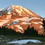
High Rock is one of the fire lookouts that was used by the Forest Service in pre-satellite days, so that staff could keep an eye out for smoke, indicating a forest fire.  Since their purpose was to observe large swaths of land, fire lookouts are always located atop high peaks and offer incredible views.  High Rock Lookout is just such a site, and still retains the original 1929 tower, perched at 5,700 feet and offering an incredible view of Mt. Rainier.

To get there, continue driving east on SR 706 from the Mt. Rainier Visitor’s Center in Ashford. After about 3 miles, turn right on Kernahan Road (also which turns into Skate Creek/FS 52), and drive 1.5 miles before taking a right on Osborn road. Immediately, take a left on FR 85 (it is unmarked), and continue 5.8 miles.  When the road forks, take the left fork onto FR 8440 (unmarked) and  continue 4.5 miles to the trailhead on the left.

An slightly longer, but smoother alternate route is to drive east on SR 706, turn right on Kernahan Road (which turns into Skate Creek/FS 52), and drive 4.6 miles before taking a right onto FR 84 (this is unmarked – it is one turn after the dirt road with the gate on the right) and keep on it for 6.8 miles, bearing right onto FR 8440 for the final 2.7 miles to the trailhead (on the right).  This route is recommended for cars lacking 4-wheel drive.

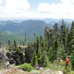
The trail is 1.6 miles each way, but with a hefty 1,400 foot elevation gain. The well-used trail is wide and in great condition, following the spine of the ridge through hemlock and silver fir with wildflowers decorating the trail in the early summer months. The path steepens as it approaches the lookout, and towards the end hikers can choose to either scramble up a steep rock slope with a 600 ft. vertical drop to the right for the most direct route to the lookout, or wind a bit further through the forest and then cut back up along the ridge, approaching the lookout from the west with the cliff to the left.

High Rock sits on a prominent point on Sawtooth Ridge, and is a popular destination for nature photographers. From the lookout, enjoy the amazing view of the south face of Mt. Rainier, the Tatoosh Range, and Mt. St. Helens and Mt. Adams to the south and east respectively.  Look down at Cora Lake, nestled in the forested valley below, and marvel at the sheer rock faces.

This hike takes on average of three hours round trip, and while the steep incline may intimidate hikers early on, the hike is finished in a short time and the view is well worth the effort. The fire lookout is open during the summer so hikers can go inside and check it out, but folks mostly spread themselves out among the rock, enjoying the sun and the spectacular views.

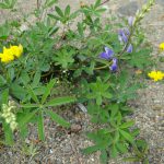
The view from the top has the most clarity in the early morning or late-afternoon, but the bugs are full-on at dusk and dawn.  even during the day, bugs will keep most hikers moving steadily through the shade.  The path is clear of snow as of early July, and bear grass, Indian paintbrush, and avalanche lilies color the landscape.

While this trail does allow dogs, dogs should be kept on a leash due to the dangerous ledge near parts of the trail.  Similarly, this path is not recommended for young children.  Since there are no public facilities, make sure to bring plenty of water and snacks.

Happy hiking to you and yours!

Posted on July 9, 2013

Stories from the Mountain: Meet Mt. Rainier’s backcountry carpenter!

The Mt. Rainier Visitors Association is beginning a new series we like to call “Stories from the Mountain.”  This will be a series of interviews with Nisqually Valley locals, National Park staff, and visitors just like you!

Meet James, one of the backcountry carpenters for Mt. Rainier.  James has been working for Mt. Rainier for 10 years, working for the Maintenance Department in a variety of roles. In 2007, James began doing historical carpentry on the back-country structures for the park.  James gets many questions about what this job entails, and which structures he works on.

Here is the deal: all of the older structures in the park are historically protected.   While visitors most often are familiar with the Visitor’s Centers and the Longmire and Paradise Lodges, anyone who has hiked in the backcountry of Mt. Rainier has likely enjoyed the site of one of the backcountry patrol cabins, shelters, or the fire lookouts that are spread throughout the park.  The National Park works to preserve these structures, along with their historical integrity, meaning that James and his co-workers maintain these buildings using traditional woodworking and masonry techniques.

There are ten backcountry patrol cabins spread throughout the park.  These are cabins that park rangers stay in while they are working in the backcountry to protect hikers and ensure park rules.  These backcountry patrol cabins include Lake George, Ipsut Creek, Golden Lakes, Lake James, Mystic Lake, Huckleberry Creek (no longer used by rangers), St. Andrews, Three Lakes, Mowich Lake, Indian Henry’s. These cabins were built between the 1930s and 1950s and are all old-growth log cabin structures. although Lake James and Mystic have been completely rebuilt. The most common work on backcountry cabins includes replacing rotten logs, and repairing storm damage to roofs, windows or beams. There are also two base camp patrol cabins located at Camp Muir and Camp Schurman.  While technically ranger stations, these structures differ from the other backcountry cabins in that they  are located at 10,080  and 9,440 feet respectively, and are made out of slabs of rock.

There are four fire-lookouts in Mt. Rainier: Shriner, Gobblers Knob, Fremont, and Tolmie.  All of the fire lookouts were built between 1932 and 1934.  Because the lookouts are all built at high points, they offer stunning views of Mt. Rainier and the surrounding areas.  However, their vantage points also leave the lookouts exposed to extreme weather conditions, and the lookouts often need to have their decks, windows, and roofing repaired.

There are also three backcountry shelters, located at Indian Bar, Camp Muir, and Summerland. These are the only backcountry structures that the public can stay in.  Interested parties should speak to a Park Ranger when obtaining the wilderness permit required for backcountry camping. Permits can be obtained from any ranger station in the park during their normal hours of operation.  More info. on obtaining overnight permits can be found here: http://www.nps.gov/mora/planyourvisit/wilderness-camping-and-hiking.htm

James has had the opportunity to visit every structure in Mt. Rainier National Park.  His favorite structures are the Ipsut cabin (complete restoration still in progress), Three Lakes, and the Indian Bar shelter. James believes that Ipsut and Three Lakes are the best examples of traditional full-scribed log-work, and he enjoys the combination of log and rock-work that comprise the Indian Bar shelter.

In term of location, James has trouble choosing a favorite place to work or visit. He likes the way Camp Schurman is built out of the rocks and often sits above the cloud deck nestled at the bow of Steamboat Prow, exactly where the Emmons Glacier and Winthrop Glacier split and become their own entities. One of his favorite views is from Tolmie Lookout where you can see all of Puget Sound, the Seattle city-scape, and the Olympic Mountains; and he also enjoys the panorama of Mt. Rainier from Fremont Lookout. James loves Indian Bar because of its plethora of animals – (he says he’s never visited the shelter without seeing a bear!), and because of the shelter’s beautiful valley setting.

While James works for the Maintenance Department year-round, (specifically for the Carpentry shop), he does most of his backcountry work during the summer, as the structures are inaccessible during the winter due to snow.  James and a co-worker usually hike to the structures they work on, and stay and work in the structures for eight-day tours in the summer and fall. The supplies and materials they use are usually flown in by helicopter in the beginning of the season, although snowmobiles, ATVS, and mules are also sometimes utilized in designated areas.

James will be working on the Camp Muir project along with his colleagues beginning the latter half of summer 2013, and his other major upcoming projects will include replacing sill logs at Lake George, and continuing to finish the rebuild of Ipsut cabin.  Good luck James, and thanks for all of your hard work!

If you have a story to tell, we’d love to hear from you! Contact us at, or call the Visitor’s Center at to be in touch.  We’d love to share your story!

Posted on July 7, 2013

Paddling around Rainier

Are you looking for other outdoor recreation for you and your family around Mt. Rainier?  A paddle on the Nisqually or Cowlitz River could be just the ticket.

The Nisqually river runs out of the park right alongside SW entrance, and through Ashford, WA. The Nisqually is recommended for more experienced paddlers, and not recommended for canoes.  The drop-in is at Skate Creek/USFS-52, where the bridge crosses over the Nisqually.  The drop in is about 5 minutes fro the Visitor Center, and the take-out is about 6 minutes away, so make sure to drop by for a visit! This run is about 11 miles, paralleling SR 706 until the takeout where Hwy 7 crosses the Nisqually in Elbe, just before Alder Lake.  A Class II and III run, this is a fast-paced run (3 hours or less) that carves through narrow slot canyons at the three-mile mark.  Scouting this section of the river is recommended, or kayaking/paddling with someone who is familiar with the river.  As the run progresses, it opens up for a few miles, allowing a few glimpses of Mt. Rainier and her glory, before passing under Hwy 7 and gently folding into Alder Lake.

To get to the Cowlitz river from our Visitor Center in Ashford, drive east on SR 706 for 3 miles,a and take a right on NSFS-52. You’ll cross over the aforementioned  drop-in for the Nisqually run, and travel on this beautiful scenic road for 22 miles before arriving in Packwood. There is camping along Skate Creek as well, though camping spots are generally taken early on weekends.

Kayaks and canoes frequent the Cowlitz in a few different sections, depending on the experience of the paddler. One put-in is at La Wis Wis campground, just a few miles east of Packwood.  There is 7.5 miles of Class II water, and the take-out is under the Packwood bridge (where USFS-52 crosses over the Cowlitz).  This run is best run at high water, April through mid-July.  It is possibly to run later in the summer/fall, but you may have to portage your vessel over shallow areas. Not recommended for young children.

A personal favorite is to put-in at the Packwood bridge (NF-52 crossing over the Cowlitz), and do the 11 mile float down to the bridge where Hwy 12 crosses over the Cowlitz.  This stretch is a fun one since the water runs at a steady pace and keeps you moving.  The run takes about 3 hours non-stop, but the mountain views are spectacular if you look back over your shoulder, and the fishing and river beaches are definitely worth pulling over for. Plan for 5-6 hours and take your time.  This section of the river is also Class II, but you’ll have to keep an eye out for sweepers (logs and log jams that can be dangerous if not avoided).  This section is not recommended for young children.

If one is looking for a family-friendly paddle, you can put in at the aforementioned bridge between Packwood and Randle where Hwy 12 crosses over Cowlitz, and float 9-10 miles until the 131 crosses over the river, just a quarter mile of Hwy 12 in Randle. This section is slow and winding, so make sure to plan by bringing plenty of water, and sunscreen.  The float takes plus or minus 5 hours non-stop, but longer if you take significant or frequent breaks. This is a great one for families, and there are plenty of spaces to camp for those that want to take it easy and make it a two-day adventure. Bring your fishing pole for this section as well!

While both rivers are accessible and gorgeous, paddlers should always take precaution.  Always paddle with a friend, scout areas that are unknown, and check your gear.  Remember that these are glacial waters and even the best swimmers will have a challenge fighting the cold if you do roll, and always wear your life jacket.  Be safe out there!

Posted on July 2, 2013