The Four Corners – Part One – Gobbler’s Knob
The History of Fire Lookouts Surrounding Mt. Rainier
Mt. Rainier National Park is host to the highest peak in Washington State, and 5th highest in the contiguous United States. The impressive bulk and prowess of Mt. Rainier extends over 100 square miles at its base, and is surrounded on all sides by a Park boundary that includes an additional 280 square miles of vegetation and wildlife.
Mt. Rainier was added as the U.S.’s 5th National Park on March 2nd, 1899. The mountain itself, which is indeed a volcano, has been towering over the area for 500,000 years! Evidence of early Native American life can be found as far back as 9,000 years, so the actual history of Rainier extends well past it’s addition to our system of National Parks. Another interesting fact about Rainier is that it is very much still active – and actually overdue to erupt based on historical trends that have been studied by the USGS. Undoubtedly there are eruptions that have occurred over the last several thousand years that have caused wildfires, which is inevitable and actually important for life to recycle itself and grow naturally in the area. Just in 2017, a wildfire was caused by lightning strikes in the north side of the park that laid waste to nearly 56,000 acres of meadows and forests.
Now that the communities surrounding Rainier have grown and populations have increased, there have been heightened efforts to plan for such events to minimize the effects on local communities and also contain events within smaller territories. With efforts to conserve and protect the animals and terrain that we’ve learned to know and love over the years, an initiative was put into effect to increase visibility of our forests and provide jobs for those struggling with the effects of the Great Depression. Born from these circumstances in 1933, the Civilian Conservation Corps (CCC) was established – and they got BUSY.
Across the country, the CCC built massive networks of trails and facilities in local, state, and national parks. Arguably one of the most important of their projects was a system of fire-watch towers spanning the highest lowland peaks surrounding Mt. Rainier and the forest-service lands in the surrounding territory. The CCC itself finally ended with the introduction of the World War Two draft and subsequent boost in labor and industry, as well as militarization of the country’s population of 18-25 year olds that made up the bulk of the CCC. However short-lived the program was, the long-term benefits of their work to make these lands accessible for all cannot be understated.
Within the Park, 7 towers were built to keep an eye out for forest fires and lightning storms. With the introduction and increased popularity of airplane surveillance, the use of the towers saw a decline due to their primitive and isolated nature. Some are still used on occasion to keep track of weather, but now mostly remain as a piece of history and acknowledgment of how far we’ve come in almost a century of innovation. Of the original 7, there are only 4 that remain accessible to the public, and their popularity has only grown over the years due to the unparalleled views they provide on their rocky precipices.
Mt. Fremont, Tolmie Peak, Shriner Peak, and Gobblers Knob rest in the 4 quadrants or “corners” of Mt. Rainier’s lowland hills. The rich history, adventure, solitude, and unmatched scenery provided by these towers remain fairly unknown to most visitors of the Park, but here we hope to shed some light on one of the oldest and most important pieces of Mt. Rainier National Park’s foundation and sustainability.
Starting at the Nisqually Entrance to Mt. Rainier, which is the only entrance that remains open year-round, this post will highlight the lowest of the 4 remaining lookouts – Gobblers Knob.
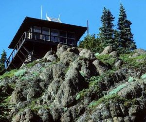
Gobblers Knob
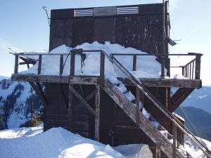
Built in 1933, Gobblers Knob still stands after 85 years of service, even after enduring a high-wind storm in 2006 that blew off the roof of the structure, which has since been repaired. A testament to the CCC’s hard and efficient labor, this structure was a fundamental addition that has withstood the tests of weather and time – long after those who built it.
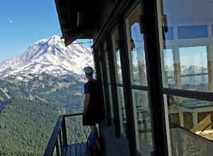
Gobblers Knob sits in the southwest corner of Mt. Rainier National Park, and is the lowest-elevation lookout at only 5,458 feet above sea level. At this elevation it is essentially at equal height with the primary destination for visitors to the Park – Paradise Visitor Center. Still, its prominence allows for extraordinary views spanning the south and west faces of Mt. Rainier, as well as the wilderness below and beyond the boundary. Even more impressive still is an immaculate view (on a clear day) of Mt. St. Helens, Goat Rocks, and the continuing Cascade Range to the north.
Unique to the other lookouts, it is the only tower that can be accessed from nearby trails inside AND outside of the Park boundary. Both approaches to the tower include passes along mountain-fed lakes: Goat Lake and Lake George, each of which are visible from the top of Gobblers Knob.
Years ago, the Westside road ran from the Nisqually Entrance and stretched to the North Puyallup River. However, due to recent years of road washouts and dangerous rock-fall lining the approach near Mt. Wow, the road has been cut short to vehicle traffic at the 3 mile mark and continued travel to the trailhead is another 3 miles on-foot or bicycle. This is perhaps a leading cause to why Gobblers Knob is not visited as often as it has been in the past, not to mention unsafe treefall conditions near the wilderness campsite by Lake George that currently has the camp inaccessible for overnight stays.
Click here for detailed information about the trail and conditions from the Westside Road.
The alternative approach is up Forest Service Road (FS) 59, which is only recommended to those with high clearance vehicles as the road is rough and riddled with potholes. This route is often sought by those who wish to bypass the larger population of day visitors to the Park, and perhaps enjoy a more secluded “back-country” experience. Still, either route will take you within Rainier’s boundaries and immerse you in the truly immense expanse of nature that has been preserved and virtually untouched for over a century.
Click here for detailed information about the trail and conditions from FS 59.
On March 13th, 1991, Gobblers Knob was placed on the National Register of Historic Places, along with the remaining 3 lookouts in Mt. Rainier’s wilderness. Truly a sight to behold, this is just one of the ancient guardians that sit atop the lower foothills; stoic reminders of our history, our progression, and how blessed we are to be even a fractional part of a chapter in the story of Mt. Rainier National Park.
Happy Hiking!